A27 Arundel bypass
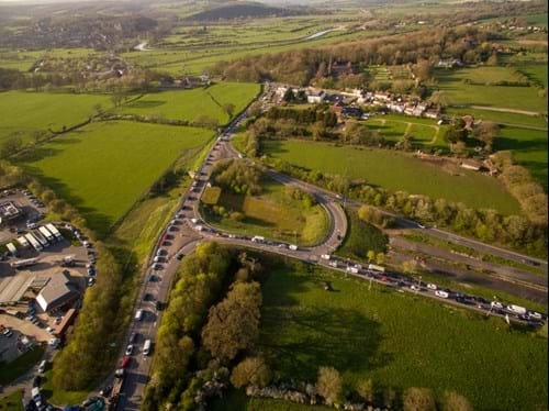
As the main road serving the south coast, the A27 is a crucial route through the south east. However, as it passes through Arundel it operates well over capacity and causes disruption and severe congestion. National Highways is therefore developing options for how the route could be improved.
Latest updates
-
08 June 2023
Deferral - further update
We updated this page back in March to confirm that the bypass scheme had been deferred to the next Roads Investment Period, known as RIS3, which covers 2025 to 2030.
We said then it would take further time to work out the next steps for the project and what the deferral meant in detail.
Whilst we continue to work through much of that detail, we can now confirm we won’t be submitting a Development Consent Order to the Planning Inspectorate this spring, as previously announced.
We can also confirm there will be no further work on the scheme at this time except for removing monitoring equipment that had already been installed.
The preferred route will remain in place whilst we work through what the deferral means for that and other aspects of scheme
We’ll be keeping this page up to date with further details as and when we can confirm them, so please check back here for all further information.
-
10 March 2023
Plans now deferred until 2025-2030
The Department for Transport has confirmed that this scheme will be deferred to RIS3 (covering 2025 to 2030) to allow time for stakeholders’ views to be fully considered. This is one of two schemes that has been deferred for consideration in the next five-year road period.
The government remains committed to the programme of enhancements within the second Road Investment Strategy (RIS2) and National Highways will also continue to deliver the remainder of our roads programme in line with our current commitments as set out in our delivery plan.
We will now be taking some time to work out finer details and next steps for the Arundel bypass.
-
17 December 2022
Our consultation has now closed
The consultation on our proposed design changes for the A27 Arundel Bypass has closed.
All responses will now be reviewed and addressed in our Consultation Report, which will be submitted to the Planning Inspectorate as part of our planning application in 2023.
You can continue to view our consultation documents in the 'Supplementary consultation 2022' section under ‘Documents’ at the bottom of this page.
-
15 November 2022
Additional consultation
There isn’t long left to tell us what you think of changes to our proposals for the A27 Arundel bypass. Please share your views, ideas and local knowledge with us before our consultation closes at 23.59 on Friday 16 December 2022.
Over the course of 2022 we've made changes to our scheme design – including further mitigation to traffic levels through Walberton – and we’d now like to present those changes and gather feedback on them.
From 16 November to 16 December 2022, we’ll be holding a Supplementary Consultation to present our revised design and seek feedback on the changes put forward.
You can take part in the consultation online from 16 November or come along to one of our events:
- Saturday 3 December 2022, Arundel Town Hall (Maltravers Street, Arundel, BN18 9AP), 10am to 4pm
- Monday 5 December 2022, Fontwell Park Racecourse, Arundel Road, Fontwell, BN18 OSY 11am to 7pm
- Saturday 10 December 2022, Walberton Pavilion, The Street, Walberton, BN18 0PJ 10am to 4pm
All consultation documents will be also available to view at the following deposit locations throughout the supplementary consultation period:
- Arun Civic Centre, 1 Maltravers Road, Littlehampton BN17 5LF, Monday to Friday 9am to 1pm and 2pm to 4pm
- Arundel Town Hall, Maltravers Street, Arundel, BN18 9AP, Monday to Friday 9am to 1pm
- Arundel Library, Surrey Street, Arundel, BN18 9DT Monday to Friday 1pm to 5pm and Thursday to Saturday 9am to 1pm
- County Hall, Chichester, West Street Chichester, PO19 1RQ, Monday to Thursday 8:30am to 5pm and Friday 8:30am to 4:30pm
- Fontwell Park Racecourse, Arundel Road, Fontwell, BN18 OSY, Monday to Friday 9am to 5pm
- South Downs Centre, North Street, Midhurst, GU29 9DH, Monday to Thursday 9am to 4:30pm and Friday 9am to 4pm
- Walberton Parish Office, The Pavilion, The Street, Walberton, BN18 0PJ, Tuesdays 9am to 12pm and Thursdays 9am to 12pm
- Worthing Library, Richmond Road, Worthing, BN11 1HD Monday to Friday 9am to 6pm and Saturday
9am to 5pm
If you would like us to email you when we have further information available, please sign up to receive notifications when we publish a new post.
DCO Submission
As a result of taking on your feedback and making changes to the design, once we have finished this consultation we plan to submit our Development Consent Order (DCO) application in Spring 2023.
Statutory Consultation update
We received thousands of consultation responses to our Statutory Consultation which took place from Tuesday 11 January to Tuesday 8 March 2022. The detailed feedback from public consultation responses, and our answers to the issues you raised, will be included in a Consultation Report which will be submitted to the Planning Inspectorate as part of our DCO application to build the scheme. All of the documents in the planning application – including the Consultation Report – will be available to the public once the application is submitted.
In the meantime, we have put together a short summary to update you on some of the findings from the Statutory Consultation, an overview of the key points that were raised in people’s responses, and what will happen next.
-
14 July 2022
Timescale changes
We are now working to a Summer 2024 start date for our work.
We’re still planning to submit our DCO by the end of 2022, but with a later start date we'll have more time to carry out the next steps for the project, such as additional consultation to get feedback on specific areas of the scheme. It also gives us a little more time to consider the best ways to strike a balance between the many competing priorities of this scheme.
We’ll keep everyone updated on any further changes to timescales.
-
10 May 2022
Record number of consultation responses as thousands get involved
We received more than 3,500 detailed responses to our public consultation this spring – a record for the Southern region - as thousands of people shared their feedback on our proposals to reduce congestion at Arundel.
Over 1,100 people visited our 19 in-person Statutory Consultation events to find out more about the designs for the Scheme, speak directly to the National Highways team and share their feedback. We also had over 3,850 visitors to our virtual consultation room.
Andrew Jackson, Programme Leader for National Highways, said “I would like to thank all who took the time to respond to our consultation, whether that was at one of our in-person events or online via our website and virtual consultation room. The Arundel bypass will connect communities, boost the local economy and add vital extra resilience to the road network.”
The next steps for the project team involve analysing all the consultation responses and taking your feedback into account as we further develop our designs for the scheme. We expect to submit our planning application to the Planning Inspectorate in 2022 and a full report on the results of this consultation will form part of the planning application – all of which will be available to the public.
Although the consultation is now closed, you can still view the consultation materials and information about the scheme on our consultation website and we'll continue to update this page with further information about the scheme.
-
09 March 2022
Our consultation is now closed
The consultation on our latest designs for the A27 Arundel Bypass has closed.
All responses will now be reviewed and addressed in a Public Consultation Summary Report, which will be available on this webpage later this year. We will then look to submit our planning application in 2022, with a decision to be made by the Secretary of State between 2023 and 2024.
You can continue to view the latest designs, watch a fly-through and get information on the measures we're taking to protect the surrounding environment, by visiting the consultation webpage where you'll still find those materials and information.
-
07 March 2022
What do you think of our proposals?
There isn’t long left to tell us what you think of our proposals for the A27 Arundel bypass as part of our public consultation. Please share your views, ideas and local knowledge with us before our consultation closes at 23.59 on Tuesday 8 March 2022.
We want to know what you think of our proposals for a bypass at Arundel. So please take part!
You can visit our virtual room and see our latest designs, watch a fly-through and get information on all aspects of our proposals and then give us your thoughts by completing our questionnaire.
You can also attend one of the following consultation events where you can see the same information and ask questions directly to our team:
- Cathedral Centre, Arundel - Thursday 24 February 11am - 7pm
- *Regis Centre Car Park, Bognor Regis - This event is in our consultation van and was due to take place on Friday 18 February, but will now be on Monday 28 February 10am – 2pm
We’re also holding a series of live chat events, accessed via our virtual exhibition on these dates:
- Saturday 26 February, 10am - 12pm
- Tuesday 1 March, 5pm - 8pm
- Friday 4 March, 10am - 1pm
Finally, you can view copies of all our documents at the following locations:
- Angmering Library
- Arun Leisure Centre
- Arundel Library
- Barnham Community Hall
- Bersted Park Community Centre
- Bognor Regis Library
- Chichester Library
- East Preston Library
- Findon Valley Library
- Goring Library
- Littlehampton Library
- Rustington Library
- Slindon Forge Village Shop
- Storrington Library
- Walberton Baptist Church Hall
If you'd like a paper copy of any of our consultation documents, we can send these to you but there may be a charge of up to £200 (including postage) for a paper copy of the Preliminary Environmental Information Report. All other consultation documents are available free of charge either in hard copy or digitally on a USB.
Please email A27Arundelbypass@highwaysengland.co.uk or call 0300 123 5000 to request a consultation document for delivery.
If you're using the links below to view our consultation documents, please note that on General Arrangement Drawing Sheet 2B The South Downs National Park Boundary can now be seen more clearly on the drawing.
-
06 December 2021
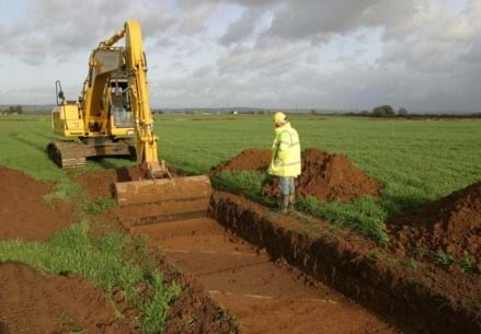
Site update – archaeology surveys
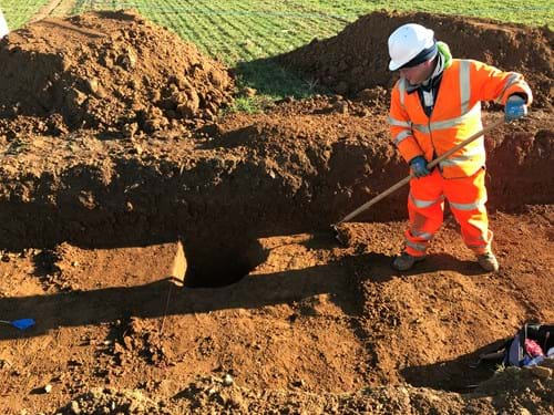
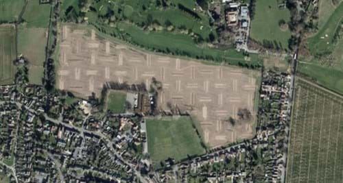
Our surveying teams are currently working to gather as much information as possible about the site of the proposed A27 Arundel bypass. As well as surveys looking at ecology, surface water and ground conditions, you may also have noticed a few archaeologists walking around with remote sensing equipment and others digging archaeological trenches.
With landowners’ permission, and working in partnership with the West Sussex county archaeology department, our team of archaeologists have planned over 600 trenches along the site of the route to make sure we understand what lies beneath the soil. This information is used to refine our design so that we can avoid or carry out some further recording of important archaeological remains that we identify.
So far, we’ve discovered quite a few new archaeological features that span the prehistoric to the modern periods and everything in between. We’ve found a few areas of Iron Age, Roman, and medieval remains, but our findings have so far been largely in line with our expectations based on what we already knew about the area.
The results have helped our understanding of the extent and significance of the archaeological resource and led to minor changes to the scheme’s design in order to minimise impacts.
What happens when we find something
When we discover a feature or artefact in one of our trenches, we carefully record information about it and where it was found, and this information will be compiled into an archaeological archive. This report will be finalised after the surveys are all complete and will continue to inform the design and mitigation for the scheme. Ultimately, the archive, including all recovered artefacts, will be shared with a local museum so it can be preserved for future generations.
We take great care to ensure that after our archaeologists have finished with the excavation of a particular trench, the land is reinstated. The ways in which this is achieved depends on the type of ground that was excavated:
- Ploughed agricultural fields: the topsoil and subsoil are removed and stored separately while we record the archaeology. Once the recording is finished and we have sign-off from West Sussex County Council’s archaeological advisor, the subsoil is returned first, and the topsoil goes back on top. Farmers will usually plough agricultural land within a few months of surveys finishing.
- Pasture: as well as the topsoil and subsoil procedure above, the grass is lifted and kept while the survey work happens and put back on top after the work is complete. Care is taken to ensure no gaps are left around the edges which could cause livestock to injure themselves. Within a few weeks of the survey work, the area that was trenched is restored to how it was before.
- Golf course: we’ll be careful to avoid positioning trenching on features that could affect the quality of the golf course. Where impact to the fairways is unavoidable, as well as the topsoil and subsoil procedure, brand new turf will be carefully laid to ensure that the fairways are in the same condition as they were before the survey work commenced.
-
03 November 2021
How will a proposed bypass improve road safety?
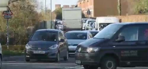
The A27 currently has a poor safety record and the accident rate on the single lane stretch at Arundel is higher than the national average for rural A roads. On average, 24 casualties are reported each year between Crossbush junction and the Fontwell (East) junction – and with the population in the area predicted to increase over the coming years this number is very likely to rise. The A27 at Arundel currently operates at 150% capacity – meaning it’s carrying many more vehicles than it was designed to. This also contributes towards the accident rate.
Congestion in and around Arundel results in some drivers seeking less suitable alternative routes, away from the existing A27. This ‘rat running’ also makes accidents more likely to happen, as these small roads in the South Downs National Park were also not designed to accommodate the volume of traffic they’re currently experiencing.
Upgrading the A27 to a dual carriageway will improve safety for the tens of thousands of drivers using it daily and encourage those who currently use small rural roads to remain on the main road instead. A modern design with fewer junctions than the existing A27 will mean journeys are faster and more reliable. Dual carriageway roads are also more resilient when accidents do occur, helping to reduce the number of times traffic reaches a total standstill.
-
05 October 2021
How will this proposed bypass boost the local economy?
Currently the A27 through Arundel operates at over 150% capacity, which causes severe congestion and long, unpredictable journey times. This makes it difficult for people who live nearby to commute for work and many local businesses struggle to recruit the staff they need as a result.
It's predicted that the A27 Arundel bypass scheme will help create new jobs in the area and will lead to productivity improvements for existing businesses. Average travel times will be significantly improved, not only on the A27 itself but in the surrounding area too.
It's not just local people who will benefit from the bypass, though. Currently, two-thirds (67%) of the traffic that uses the A27 between Crossbush roundabout and Causeway roundabout is through-traffic. Local businesses tell us the long queues make Arundel a less attractive destination for their customers and clients, with many visitors’ first experience of the town being a frustrating one. After the construction of the proposed bypass, the full length of the existing A27 through Arundel will be retained, allowing visitors easy access to the town while through-traffic is able to travel along the bypass.
-
07 September 2021
Site surveys: What are we looking for and why is data gathering so important?
Our surveying teams are working to understand as much as possible about the site of the proposed bypass. With landowners’ permission, and working with the relevant local authorities and licensing bodies, our teams will be out and about on site over the next few weeks. You might notice them conducting this vital work, so we wanted to explain what data is being gathered and why it’s important, so please visit our 'Project Information' section below and scroll down to the 'survey's menu. There you can read about how we’re looking at archaeological deposits, trees, surface water and ecology and how all this will inform the detailed design of the road.
-
30 June 2021
What’s going on?
Highways England is carrying out surveys on land along the Grey route which we announced last year as the preferred route for the proposed bypass.
These surveys will give us a clear picture of the ground conditions along the route and we’ll get a good understanding of the type of soils, rocks and groundwater there. This information will help us design and build a safe bypass and will help us reduce the road’s impact on the environment and local community.
At the moment we’re surveying along the route from Crossbush to west of Walberton where the Arundel Road meets the A27 in Walberton.
We’re carrying out these surveys on plots of land where we have been given permission by the relevant landowner and all work has been agreed and authorised by the Environment Agency or local councils.
Our investigation work also complies with Section 61 of the Control of Pollution Act (1974), which places restrictions on noisy work.
What you’ll see
Some of our surveys involve drilling holes and we’ll be using monitoring devices to gauge water and gas levels.
Will local wildlife, plants or historical sites be disturbed by the work?
We’ve already carried out extensive environmental surveys, including bat, badger, reptile, bird and tree surveys. These environmental surveys will continue over the coming months in parallel with the ground investigation work you currently see.
The holes we need to make have been located to avoid environmentally sensitive locations, where possible. There will be ecologists, survey supervisors and archaeologists available during the work to make sure the impact of our work is kept to a minimum.
Who is doing this work?
A company called Arcadis are carrying out a lot of investigations on our behalf, along with a company called BAM Nuttall. You will only see staff from these organisations or from Highways England.
All personnel will be identifiable by their high visibility clothing.
How long will you be there?
We’re aiming to complete these surveys as soon as possible and with minimal disruption. We started them last year and they will be finished in the winter.
We apologise for any inconvenience that may be caused while they are being carried out.
Our proposed bypass will improve safety and reduce congestion in Arundel, which has caused the town problems for many years.
-
18 February 2021
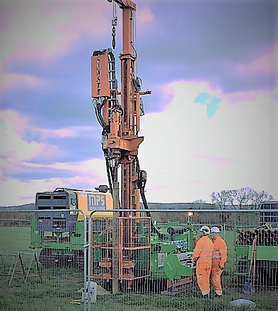
Surveys and ground investigation along our preferred route
This month (February 2021) and until summer 2021 you’ll see our contractors doing ground investigation (GI) surveys on the land along the proposed route of the bypass. We need to find out more about the soils, rocks and groundwater along the route and this information will help us design the road in a way that seeks to minimise impact on the environment and local community as much as possible.
GI surveys are carried out using drilling rigs with crews of varying size dependant on the type of survey. We’ll be setting up temporary site compounds for the work, which we’re setting up during the course of the works.
There is the possibility of some night working on the road and on private land, depending on what we’ve agreed with each private landowner. The work we’re doing in February to summer 2021 is mainly on private land that has no public access, such as farmland.
Our ground investigation work is a continuation of the survey work we’ve been doing since April 2017 and which continues this year. That work includes:- topographical surveys that started in September 2020 and will finish this month (February 2021);
- drainage and road surface surveys, which will both take place on the A27. There will be traffic management on the road for these and they’re taking place this spring;
- ecology surveys which will continue to run throughout the year;
- archaeological trial trenching which will take place along the preferred route later this year;
Our site surveyors will work in accordance with Covid-19 social distancing measures and latest government guidance.
-
15 October 2020
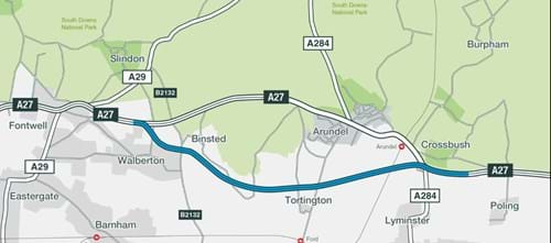
Our preferred route
We’ve chosen Grey (Option 5BV1) as our preferred route for the A27 Arundel bypass.
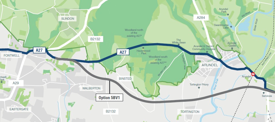
* Woodland north of A27 includes Dalesdown Wood, Danes Wood, Goblestubb's Copse, Madehurst Wood, Rewell Wood, Rough Copse, Screens Wood, Sherwood Rough, The Rough, The Waterwoods, West Stubbs Copse.
** Woodland south of A27 includes Ash Piece, Barn's Copse, Binstead Park, Binsted Wood, Brickklin Copse, Brickklin Piece, Fowler's Copse, Furzefield Copse, Hundredhouse Copse, Lake Copse, Little Dane's Wood, Paine's Wood, Pedler's Croft, Pinewoods, Singer's Piece, Spinningwheel Copse, Steward's Copse, The Shaw, Tortington Common, Wincher's Copse, Threecomer Wood.
Considerations
We have weighed up a range of considerations to identify our new preferred route.
These have included:
- How well the proposed designs would meet the scheme objectives
- Potential impacts on local communities and the environment around Arundel
- The extent to which the proposals would comply with planning policy
- Feedback received during our public consultation process
- The cost of delivering the scheme and the value-for-money that would be achieved by doing so
While there are no easy answers to the challenges of improving the A27 around Arundel, the results of our extensive assessment work have clearly identified Grey as the best long-term solution.
You’ll find more details about the proposed route in our Preferred Route Announcement brochure and in the Documents section below.
What happens next?
Now we have announced our preferred route, we will carry out extensive surveys and investigations to help us design the scheme in more detail.
These investigations will inform a landscape level assessment and support the development of mitigation measures to ensure the proposal is as sensitive to the environment and existing landscape as possible. As part of this process your views will be sought on the preliminary design and on the results of those further environmental assessments that we will have undertaken before we submit our application for a Development Consent Order.
This means you will have a further opportunity to shape the scheme as the detailed design develops.
We will work with key stakeholders, including local authorities and statutory environmental bodies over the coming months to ensure this consultation is suited to local needs, and we will publicise the details of the consultation and how you can take part, in due course.
-
01 October 2020
Ecological surveys
The A27 Arundel bypass scheme is currently carrying out ecological surveys to help identify habitats and species and understand how we manage our impacts on them.
These important surveys will form part of our environmental impact assessment and will help us as we develop our planning proposals.
Find out more about our survey work and our ecologists by watching our video:
-
02 March 2020
Next milestone for Arundel scheme
The next milestone for the A27 Arundel scheme will be when we make our preferred route announcement this autumn. The full consultation report will be made available when we make this announcement.
-
31 January 2020
Further review period for consultation
The 2019 options consultation on proposals to improve the A27 at Arundel ran from 30 August until midnight on 24 October 2019. We’d like to thank everyone who took the time to provide feedback.
As part of our work to collate and review the responses to the consultation, we identified some issues around the way certain pieces of information were presented. Following this, we undertook further reviews of the published documents and have identified some errors. As a result, we are holding a further review period from 3 February until 11.59pm on 1 March 2020.
-
29 January 2020
Elected Representatives' Forum
The Elected Representatives’ Forum provides a way for Highways England to engage with communities local to the A27 Arundel Bypass scheme. The forum will help local communities, via their elected representatives, to find accurate, up-to-date information about the scheme, through the consultation and planning stages and what they can expect – for example, emerging evidence and design options. It is also a way for the local communities to understand what the scheme means for them and how it will progress over the years.
The Forum most recently met in September 2019. You can find out what was discussed in this meeting below. All other minutes are held in the 'Elected Representatives Forum' section below.
If you have any questions or would like to get in touch with the A27 Arundel Bypass project team, please email: a27arundelbypass@nationalhighways.co.uk.
Project information
By making changes to the A27 at Arundel we’re aiming to:
- Improve safety
- Increase the capacity of the road
- Reduce congestion and travel time
- Have as little impact as possible on the environment
- Protect and enhance the quality of the surrounding environment through high quality design
- Respect the South Downs National Park and its special qualities in our decision-making
We need this scheme because the A27 through Arundel causes a daily build up of traffic that costs commuters, businesses, communities and visitors valuable time and money. In fact, the congestions costs businesses millions of pounds a year. The road also cuts off communities and makes every day trips longer and more difficult.
Supplementary consultation - 16 November to 16 December
Statutory consultation - 11 January to 8 March 2022
Further review period - 3 February to 1 March 2020
Further options consultation - 30 August to 24 October 2019
Options consultation - July to October 2017
Our surveying teams are working to gather as much information as possible about the site of the proposed A27 Arundel bypass. With landowners’ permission, and working with the relevant local authorities and licensing bodies, our teams will be out and about on site carrying out surveys. You might notice them conducting this vital work, so we’re taking a closer look below to explain what data is being gathered and why it’s so important for our design team.
Archaeological trial trenching
We’re about to begin archaeological investigations, which means we’ll be looking for - and recording - any archaeological findings. You may see some of our archaeology team starting the surveys in September and continuing over the coming months. Whether it’s prehistoric animal bones, stone-age hand tools, medieval farm equipment or Victorian military remains, we’ll carefully record everything we find and produce a report for the public record.
We are working with the archaeology team at West Sussex County Council to plan this work. The results of these surveys will provide our road design team with valuable evidence about the archaeology of the site, allowing us to make sure we’re minimising the impact of the road design on any historical remains we find. We expect most of this archaeology work to take place on weekdays.
Tree surveys
Our Arboricultural team of tree specialists look at the areas on site where existing trees might be affected during the construction of the proposed road. They visit the site and examine the trees, recording information about their location, size, condition, quality and species. Our tree specialists work in small teams and their surveys are not invasive. The tree survey data will be used to inform the design team about trees on site, including their required canopy and root protection zones. Although the proposed route of the road does not pass through any ancient woodland at all, there are still many significant trees on the site and the Arboricultural survey will help us to understand how we can design the road to have the smallest possible impact on existing trees in the area and also where would be the best areas to plant new trees.
Water surveys
Our water survey team are working to gather as much information as possible about surface water conditions at the site of the proposed road – like the condition of rivers and streams, and information about flood plains. This ‘baseline data’ will be gathered by small teams of water surveyors over the coming weeks. You might notice people with bottles gathering water samples from specific points in the streams and rivers on site. This is to make sure we understand as much as possible about the current water quality so that our design team can put in place the best type of drainage measures to protect it as they develop plans for the road. You might also see people using a hand-held ‘flow meter’ – a device that tells us how fast the water is moving along a water course. All these observations are repeated at different times of year to make sure seasonal changes are taken into account.
Ecological surveys
Our ecology team work around the clock to gather information about the ecology of the site. This includes information about the wildlife habitats as well as individual species, and they’ll be looking on land, in the watercourses, and up in the air! Ecologists will be on site most weeks, looking for different things depending on the season and the weather conditions. Surveys are ongoing to look for evidence of animals like bats, great crested newts, otters and water voles – protected species that, if discovered, will be carefully considered as we continue designing the road. This might mean for example avoiding valuable habitat where possible, creating new habitats and planning for the careful relocation of animals.
Due to the nature of the work, our ecology teams might be on site at all times of the day and night. Bat surveying, for example, needs to happen at dusk and into the evening to observe bats entering and leaving their roosts.
The information gathered by the ecologists is vital for the design team, enabling them to make informed decisions about areas of valuable habitat on site and also letting them know where extra habitat might need to be created. You can find out more about the work of the ecology team by watching our video from earlier in the project.
Documents
General Arrangement cover sheet
General Arrangement drawing sheets
General Arrangement drawing 2A
General Arrangement drawing 2B
Statement of Community Consultation
PEIR Volume 3
- Figure 1-1
- Figure 2-1
- Figure 6-1
- Figure 6-2
- Figure 6-3
- Figure 7-1
- Figure 7-2
- Figure 7-3
- Figure 7-4
- Figure 7-5
- Figure 7-6
- Figure 7-7
- Figure 7-8
- Figure 7-9
- Figure 7-10
- Figure 7-11
- Figure 8-1
- Figure 8-2
- Figure 9-1
- Figure 9-2
- Figure 9-3
- Figure 9-4
- Figure 11-1
- Figure 11-2
- Figure 11-3
- Figure 11-4
- Figure 12-1
- Figure 12-2
- Figure 13-1
- Figure 13-2
- Figure 13-3
- Figure 13-4
- Figure 13-5
- Figure 13-6
- Figure 15-1
PEIR Volume 4a (Technical Appendices)
PEIR Volume 4b (Technical Appendices)
PEIR Volume 4c (Technical Appendices)
You'll find the following booklets and forms at https://nationalhighways.co.uk/publications/ where you can filter to ‘Land, Property and Compensation’:
Your property and our road proposals
Your property and discretionary purchase
Your property and compulsory purchase
How to claim for the effects on your property of new or altered roads
Claim for compensation
Your property and blight
Your property and compensation or mitigation for the effects of our road proposals
A27 Arundel Bypass Preferred Route Announcement Brochure
A27 Arundel Bypass Preferred Route Announcement Map
A27 Arundel Bypass Report on Further Consultation
A27 Arundel Bypass Report on Further Consultation Appendix A-D1
A27 Arundel Bypass Report on Further Consultation Appendix D2-H
A27 Arundel Bypass Scheme Assessment Report
A27 Arundel Bypass Scheme Assessment Report Appendix A-C
A27 Arundel Bypass Scheme Assessment Report Appendix D-G
Development Consent Order Leaflet
Further review period 2020 (poster)
Further Consultation Brochure Errata (3 Feb 2020)
Combined Modelling & Appraisal Report Errata (3 Feb 2020)
Environmental Sensitivity Testing Technical Note Errata (3 Feb 2020)
Environmental Assessment Report Errata (3 Feb 2020)
Local Roads Study Errata (3 Feb 2020)
Scheme Assessment Report Errata (3 Feb 2020)
South Downs National Park Special Qualities Errata (3 Feb 2020)
Biodiversity Technical Appendices Errata (3 February 2020)
Biodiversity Technical Appendix Attachment A Errata (3 Feb 2020)
Biodiversity Technical Appendix Attachments B-H Errata (3 Feb 2020)
Environmental Assessment report – biodiversity technical appendices errata
Letter to Residents – A27 Arundel Bypass Update
A27 Arundel Bypass Further Consultation Brochure
A27 Arundel Bypass Further Consultation Questionnaire
A27 Arundel Bypass - Approach to public consultation
A27 Arundel Bypass Further Consultation Environmental Assessment Report
Environmental Assessment Report Errata 16 September 2019
A27 Arundel Bypass - Environmental Sensitivity Testing Technical Note
A27 Arundel Bypass Further Consultation Interim Scheme Assessment Report
Interim Scheme Assessment Report Errata 16 September 2019
A27 Arundel Bypass Further Consultation Combined Modelling and Appraisal Report
A27 Arundel Bypass Further Consultation Combined Modelling and Appraisal Report Appendix
A27 Arundel Bypass Further Consultation Satellite Maps 1 of 2
A27 Arundel Bypass Further Consultation Satellite Maps 2 of 2
A27 Arundel Bypass Further Consultation Traffic Heat Maps
A27 Arundel Bypass Further Consultation Scheme Options Map
A27 Arundel Bypass Further Consultation Display Posters
A27 Arundel Bypass Further Consultation Exhibition Banners
A27 Arundel Bypass Further Consultation Exhibition Display Boards
Further Public Consultation Planning Policy Summary
A27 Arundel Bypass - Western tie-in local roads study
A27 Arundel Bypass - Western tie-in local roads study - appendices
Preferred Route Announcement brochure 2018
Report on public consultation 2018
Report on public consultation 2018 - appendix 1
Report on public consultation 2018 - appendix 2
Report on public consultation 2018 - appendix 3
A27 Arundel Bypass - Scheme assessment report
A27 Arundel Bypass - Scheme assessment report - Appendix A
A27 Arundel Bypass - Scheme assessment report - Appendices B,C,D,E
A27 Arundel Bypass Scheme Assessment Report - Erratum
Facilities for Walkers, Cyclists and Horse Riders
Technical Appraisal Appendices A-C
Technical Appraisal Appendices D-E
Technical Appraisal Appendices F-G
Technical Appraisal Appendices H-O
Technical Appraisal Report Addendum
Environment and Appraisal Summary
Environmental Study Report Appendix Part 1
-
Elected Representatives Forum - Minutes (February 2023)
Please note this session took place prior to the 10 March Ministerial announcement and therefore the content does not reflect the most recent project update. - Elected Representatives Forum - Minutes (November 2022)
- Elected Representatives Forum - Minutes (July 2022)
- Elected Representatives Forum – Minutes (May 2022) approved with majority approval by the Elected Representatives Forum.
- Elected Representatives Forum - Minutes (February 2022)
- Elected Representatives Forum - Minutes (November 2021)
- Elected Representatives Forum - Minutes (September 2021)
- Elected Representatives Forum - Minutes (July 2021)
- Elected Representatives Forum - Minutes (May 2021)
- Elected Representatives Forum - Minutes (March 2021)
- Elected Representatives Forum - Minutes (September 2019)
- Elected Representatives Forum - Minutes (June 2019)
- Elected Representatives Forum - Minutes (March 2019)
- Elected Representatives Forum - Minutes (November 2018)
- Elected Representatives Forum - Terms of Reference
Technical reports
Highways England Delivery Plan 2015 to 2020
Freedom of information request: A27 Arundel bypass proposals
A27 Arundel Improvement Stakeholder meeting July 2015
A27 Arundel Improvement Stakeholder meeting May 2016
Traffic Data Collection Report
A27 Arundel Bypass update letter to residents
Spotlight on Connecting West Sussex
Connecting West Sussex: The business opportunity of a better A27 at Arundel
Related Road projects
Traffic information
Information about scheduled roadworks and events on our motorways and major roads.X
Manage your cookie preferences to view the content on this page
Sign up for updates!
Keep up to date with what's happening on this scheme by signing up to our updates.
